

Products Description
INJIE Multi-Function Night Vision System Technical Specification
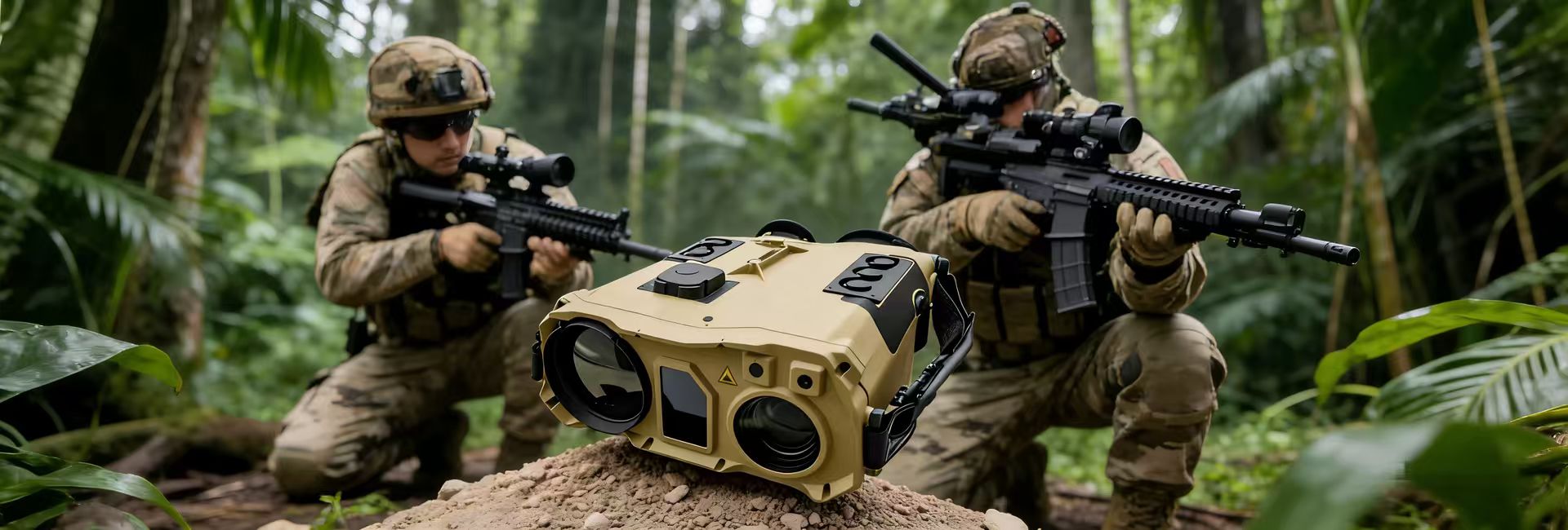
I. Applications
The Multi-Function Night Vision System is engineered for surveillance of terrain, targets, and射击 effects during nighttime or adverse weather conditions. This all-in-one device integrates infrared detection, low-light sensing, visible light imaging, laser ranging, GPS positioning, an electronic compass, and a storage module. It delivers long-range day/night reconnaissance capabilities, acquiring target geolocation coordinates, azimuth, and distance data to significantly enhance situational awareness around the clock.
II. Key Features
- Multi-Modal Imaging: Supports Infrared, Low-Light, and Image Fusion modes.
- Precision Ranging & Positioning: Features eye-safe laser ranging, high-precision self-localization, and target direction-finding capabilities.
- Data Management: Equipped with removable storage for recording; supports rapid data destruction and secure export.
- Expandable Connectivity: Optional Wi-Fi, Bluetooth, or 4G/5G communication modules, along with voice recognition for assisted operation.
III. Technical Specifications
Detection Range and Accuracy
Recognition Distance: Under favorable meteorological conditions (temperature ≤20°C, relative humidity ≤80%, visibility ≥8km, illumination 105 to 1×10⁻³ lux) and clear line-of-sight, the effective vehicle recognition range shall be ≥5km (pre-fusion).- Laser Ranging: Range of 20m to 5km (under favorable conditions) with an error of ≤5m and a repetition rate of ≥1Hz.
- Positioning Accuracy:
- Self-Localization: Error ≤10m (CEP) using the positioning module.
- Target Location: Azimuth error ≤0.5° (RMS); location accuracy for a target at 5km shall be ≤50m (CEP).
- Coordinate System: Uses CGCS2000, with display options for both latitude/longitude and rectangular coordinates.
Imaging Field of View
- FOV: Maximum field of view ≥6.1°×4.8°.
- Zoom Capabilities: The Infrared channel features electronic zoom, while the Low-Light channel features optical zoom to enhance surveillance effectiveness.
Recording and Storage
- Data Overlay: Capable of overlaying target azimuth, date, and time onto images and video.
- Capacity: Storage capacity ≥128GB with user-replaceable media.
- Export: Content can be easily exported. Video resolution matches or exceeds the built-in display resolution, with a frame rate of ≥24±1Hz.
Visual Enhancement
- Image Fusion: Merges infrared and low-light band images for significant visual enhancement.
- Fog Penetration: Under visibility conditions of ≤5km, fog penetration capability is ≥1.5× the visibility range.
- Image Processing: Includes contrast adjustment and electronic zoom (1.0× to 4.0×).
Portability
- Handheld Operation: Designed for single-person handheld use.
- Weight: Unit weight ≤2.5kg (including host and batteries); total carry weight with necessary accessories ≤3.5kg.
Power and Operation
- Battery Life: Continuous operating time ≥6 hours (at 20°C).
Interfaces
- Connectivity: Standard USB (USB 3.0, Type-C), RS232 data interface, standard PAL video output, and external charging interface.
Environmental
- Operating Temperature: -40°C to +50°C.